El ciclismo en carretera y el de montaña son excelentes formas de ver el mundo y, con el auge cada vez mayor de los desplazamientos sostenibles , la bicicleta es una de las mejores formas de irse de aventuras. Algunos de los viajes descritos a continuación solo duran un día y se hacen bien en bicicleta de alquiler, mientras que otros están reservados para ciclistas curtidos. Sea cual sea tu nivel, desde aquí podrás empezar a inspirarte.
Ruta del Telón de Acero, Europa
 Entre otros lugares, la ruta del Telón de Acero te hará recorrer los tranquilos viñedos de Moravia — Shutterstock Longitud: unos 10 000 kilómetros Puntos de inicio y fin: Kirkenes (Noruega)
/Tsarevo (Bulgaria)
Duración: unos tres meses Arrancamos con una grande. La ruta del Telón de Acero —o ruta EuroVelo
13, para darle un nombre ligeramente más prosaico— es una de las más épicas del mundo. Con inicio en el extremo norte de Europa
, los ciclistas suelen ir hacia el sur, en primavera para escapar del calor extenuante de los meses estivales. Como habrás deducido, la ruta sigue la línea del «telón de acero» hacia el sur, siguiendo la costa báltica
, antes de cruzar Alemania, bordear la República Checa
, rondar Eslovaquia y continuar por las fronteras de Hungría
, Rumanía y Bulgaria antes de terminar en el Mar Negro. Descubrirás maravillosos paisajes europeos, del inhóspito vacío de los bosques de Finlandia
hasta los tranquilos viñedos
de la República Checa, pasando por aldeas montañosas hasta alcanzar la soleada recompensa de la costa
. Es una de las grandes aventuras del continente y una lección viviente de historia moderna de Europa. Si deseas más información, podrías leerte El ciclista que salió al frío, un libro de Tim Moore, que recorrió toda la ruta en una bicicleta de carretera alemana de la era comunista. También puedes leer lo más destacado aquí
.
Entre otros lugares, la ruta del Telón de Acero te hará recorrer los tranquilos viñedos de Moravia — Shutterstock Longitud: unos 10 000 kilómetros Puntos de inicio y fin: Kirkenes (Noruega)
/Tsarevo (Bulgaria)
Duración: unos tres meses Arrancamos con una grande. La ruta del Telón de Acero —o ruta EuroVelo
13, para darle un nombre ligeramente más prosaico— es una de las más épicas del mundo. Con inicio en el extremo norte de Europa
, los ciclistas suelen ir hacia el sur, en primavera para escapar del calor extenuante de los meses estivales. Como habrás deducido, la ruta sigue la línea del «telón de acero» hacia el sur, siguiendo la costa báltica
, antes de cruzar Alemania, bordear la República Checa
, rondar Eslovaquia y continuar por las fronteras de Hungría
, Rumanía y Bulgaria antes de terminar en el Mar Negro. Descubrirás maravillosos paisajes europeos, del inhóspito vacío de los bosques de Finlandia
hasta los tranquilos viñedos
de la República Checa, pasando por aldeas montañosas hasta alcanzar la soleada recompensa de la costa
. Es una de las grandes aventuras del continente y una lección viviente de historia moderna de Europa. Si deseas más información, podrías leerte El ciclista que salió al frío, un libro de Tim Moore, que recorrió toda la ruta en una bicicleta de carretera alemana de la era comunista. También puedes leer lo más destacado aquí
.
Ruta de las Capitales, Países Bajos y Alemania
 Consigue tu postal de vistas holandesas en la ruta de las Capitales — Shutterstock
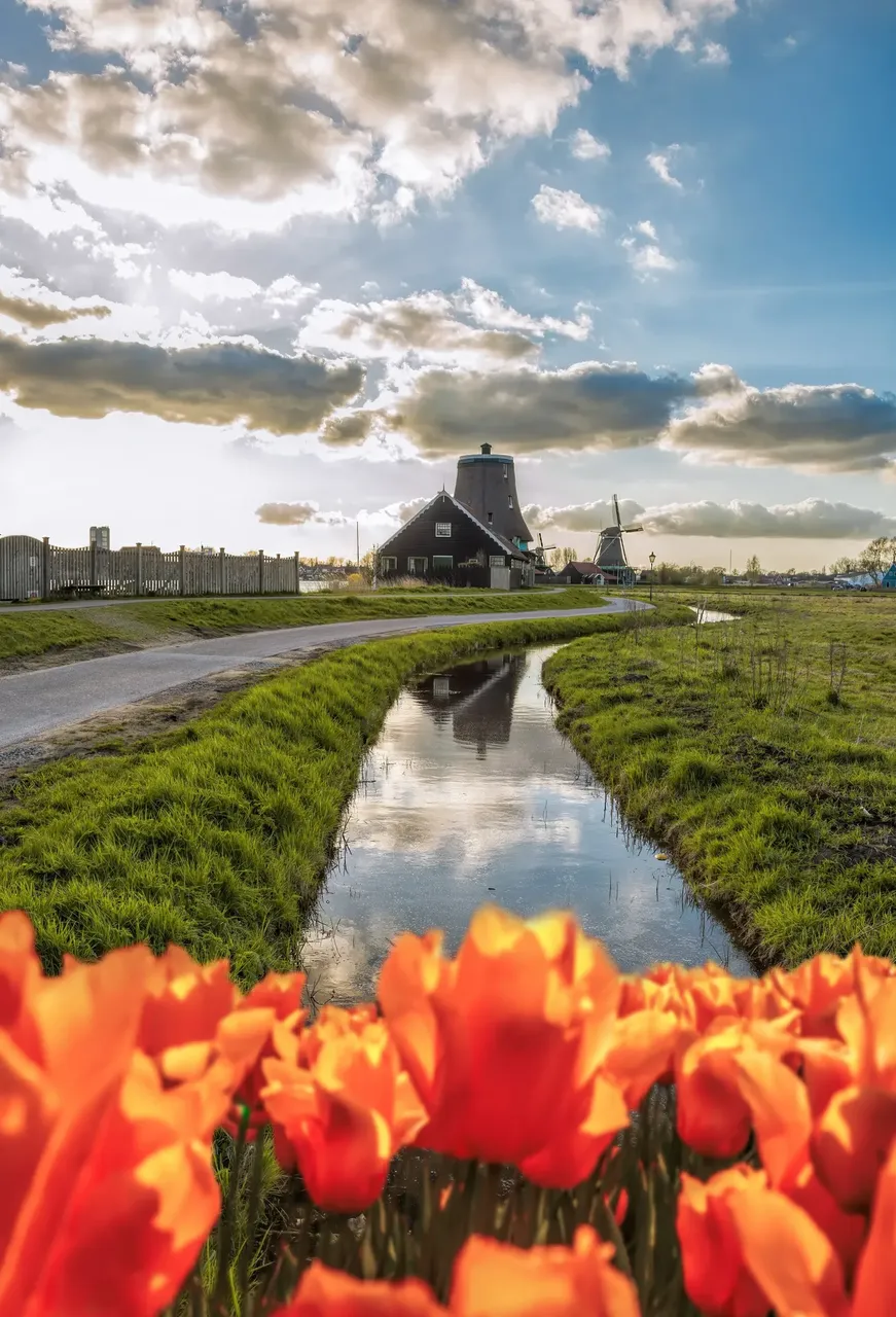
Longitud: 690 kilómetros Puntos de inicio y fin: Róterdam (Países Bajos), Berlín (Alemania) Duración: entre cuatro y cinco días Ahora, otra ruta europea pero más sencilla y llana a través de Países Bajos y Alemania con destino Berlín . También es una ruta EuroVelo, en esta ocasión EV2 (y, técnicamente, va de Dublín a Moscú), pero este tramo recorre senderos cómodos, pavimentados y bien señalizados que atraviesan campos de tulipanes, bosques rebosantes de pájaros cantores y soleados prados. (Por cierto, un apunte breve sobre el proyecto EuroVelo: consta de 17 recorridos de larga distancia con más de 90 000 kilómetros de pistas ciclistas que enlazan importantes ciudades del continente y todas diseñadas para personas que deseen explorar Europa de forma saludable, sostenible y sin fronteras. Una idea fantástica.) Pararás cada cierto tiempo a comer algo —pan recién hecho, quesos locales, una cervecería de pueblo o una bodega al final del día como recompensa— pero la mayor parte del tiempo lo pasarás disfrutando el paisaje. La ruta es lo suficientemente larga para suponer un reto, pero no tan extenuante como para parecer un castigo y perfecta si quieres hacer un recorrido largo en bici pero no sabes dónde o cómo empezar.
Kaido de Shimanami, Japón
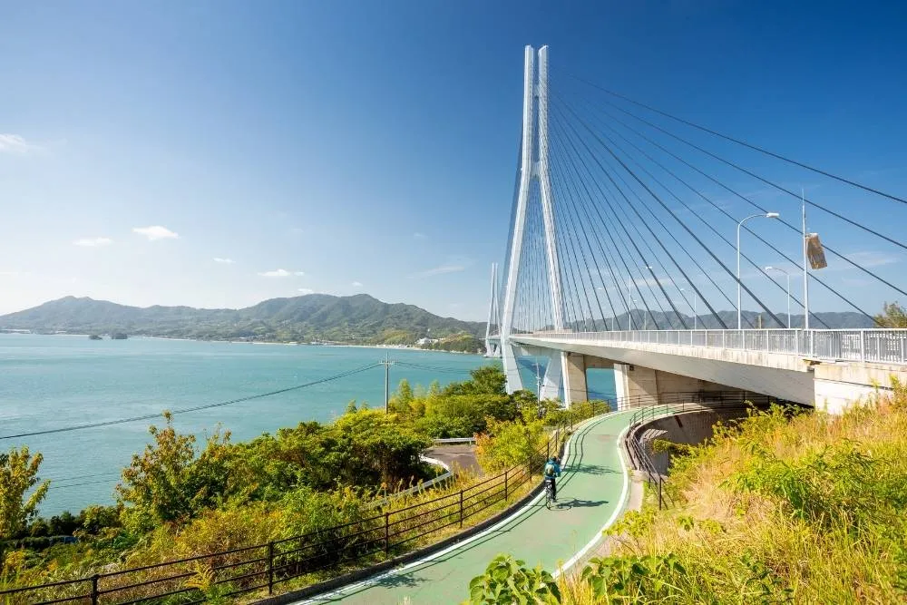 El Gran Puente de Tatara es uno de los diversos puentes que conectan las islas japonesas de Honshu y Shikoku — Shutterstock Longitud: 70 kilómetros Puntos de inicio y fin: ciudad de Onomichi, Honshu/ciudad de Imabari, Shikoku (Japón)
Duración: entre 4 y 10 horas, dependiendo de las paradas Un kaido («carretera») es una ruta comercial que data del periodo Edo de la historia de Japón y muchos de ellos aún se usan actualmente. Esta en concreto no es tan venerable, ya que se abrió en 1999, pero te mostrará algunos de los paisajes antiguos de Japón, varias aldeas pequeñas y seis islas en un mar de interior. La ruta conecta las grandes islas de Shikoku y Honshu pero, mediante una red de puentes, también llega a Mukaishima, Innoshima, Ikuchijima, Omishima, Hakatajima y Oshima. Por el camino, pasarás por un museo dedicado Hirayama Ikuo, uno de los pintores más famosos de Japón, y un templo construido por un empresario adinerado para su madre. En cada extremo de la ruta hay oficinas de alquiler de bicicletas (además de otros puntos de recogida y entrega por el camino) y el tramo que hay entre Honshu y la isla de Mukaishima se puede hacer en un breve trayecto en ferry.
El Gran Puente de Tatara es uno de los diversos puentes que conectan las islas japonesas de Honshu y Shikoku — Shutterstock Longitud: 70 kilómetros Puntos de inicio y fin: ciudad de Onomichi, Honshu/ciudad de Imabari, Shikoku (Japón)
Duración: entre 4 y 10 horas, dependiendo de las paradas Un kaido («carretera») es una ruta comercial que data del periodo Edo de la historia de Japón y muchos de ellos aún se usan actualmente. Esta en concreto no es tan venerable, ya que se abrió en 1999, pero te mostrará algunos de los paisajes antiguos de Japón, varias aldeas pequeñas y seis islas en un mar de interior. La ruta conecta las grandes islas de Shikoku y Honshu pero, mediante una red de puentes, también llega a Mukaishima, Innoshima, Ikuchijima, Omishima, Hakatajima y Oshima. Por el camino, pasarás por un museo dedicado Hirayama Ikuo, uno de los pintores más famosos de Japón, y un templo construido por un empresario adinerado para su madre. En cada extremo de la ruta hay oficinas de alquiler de bicicletas (además de otros puntos de recogida y entrega por el camino) y el tramo que hay entre Honshu y la isla de Mukaishima se puede hacer en un breve trayecto en ferry.
La Ruta Jardín, Sudáfrica
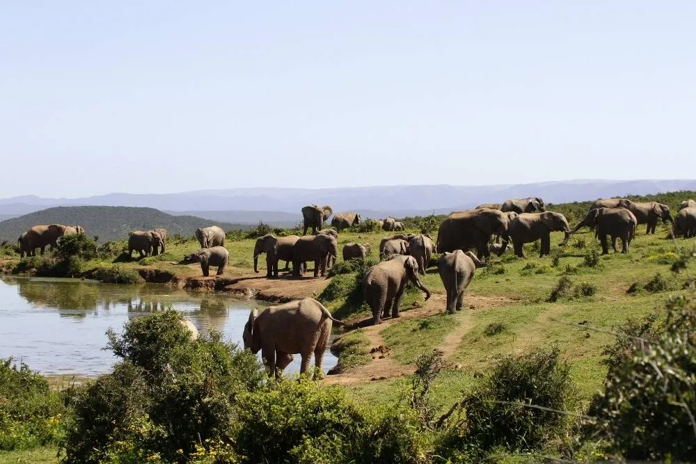 Encontrarás el parque nacional de los Elefantes de Addo fuera de la ruta principal — Shutterstock
Longitud: 750 kilómetros Puntos de inicio y fin: Ciudad del Cabo/Port Elizabeth (Sudáfrica) Duración: entre cinco y siete días La Ruta Jardín es un maravilloso sendero por la costa que oficialmente solo tiene 300 kilómetros desde Mosselbaai, en el oeste, hasta Stormsrivier, en el este, aunque la mayoría de viajeros lo amplían para que incluya una breve parada urbana en los extremos. La idea es no apresurarse: hay montones de cosas que ver, playas en las que relajarse, puestos de observación a los que llegar y viñedos que visitar. Aun pedaleando cinco o seis horas diarias a paso relajado, progresarás a buen ritmo. El terreno no pasa demasiada factura, las carreteras son tranquilas y el paisaje cambia con cada día que pasa. Tanto te podrás encontrar con la fauna local en el bosque como ver delfines nadando junto a la costa. Incluso podrás recorrer en bici los bosques y adentrarte en el parque nacional de los Elefantes de Addo, donde podrás ver elefantes (obviamente), además de rinocerontes y búfalos, entre otros animales.
La Parenzana, Italia, Eslovenia y Croacia
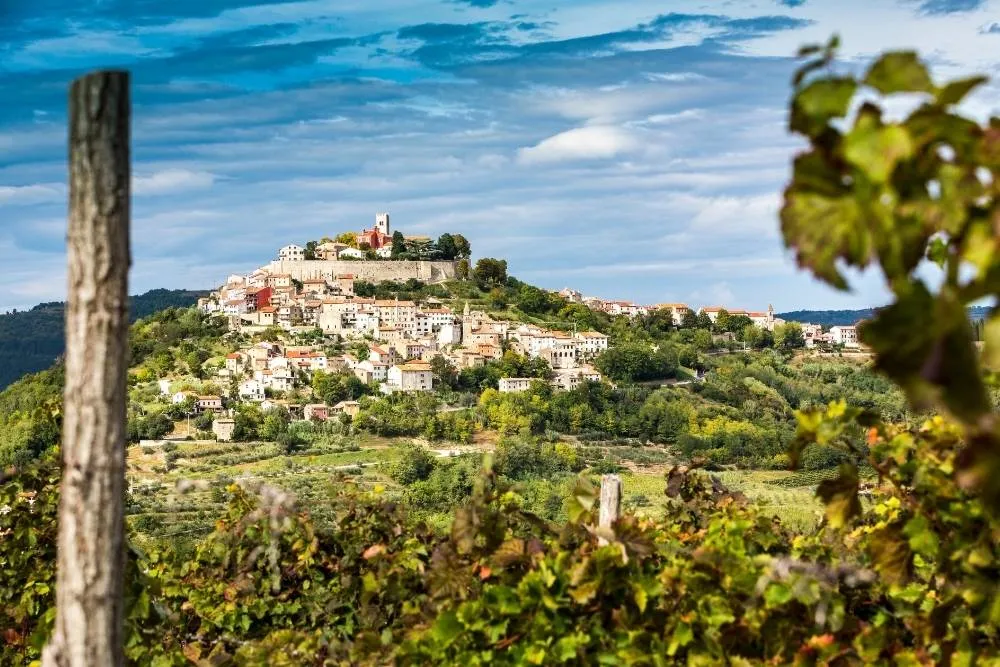 La aldea de Motovun, en Croacia, se encuentra cerca del final de la Parenzana — Shutterstock
Longitud: 123 kilómetros Puntos de inicio y fin: Trieste (Italia)/Poreč (Croacia) Duración: uno o dos días Esta es una de las rutas más cortas de la lista y, al igual que la Ruta de las Capitales, es ideal para quienes deseen adentrarse en rutas más largas. También atraviesa tres países (Italia , Eslovenia y Croacia), por lo que resulta ideal para conocer mundo. Es una ruta cómoda, ya que sigue una antigua vía estrecha de ferrocarril, y los trenes no son muy aficionados a las pendientes. Aunque sea una ruta corta, tiene muchísimo que ofrecer. Siempre tendrás vistas al mar de un lado y vistas a las montañas a lo lejos del otro, en especial en Eslovenia. Los aficionados a la historia , la buena comida y el buen tiempo también disfrutarán de esta ruta, ya que pasa por reliquias del antiguo Imperio austrohúngaro en pequeñas aldeas y los pescados y mariscos locales son increíbles. Incluso podrás dividir el viaje en etapas y pasar la noche en preciosos lugares como la ciudad portuaria medieval de Koper o la vasta y apacible ciudad costera de Umag.
Going-to-the-Sun Road, Estados Unidos
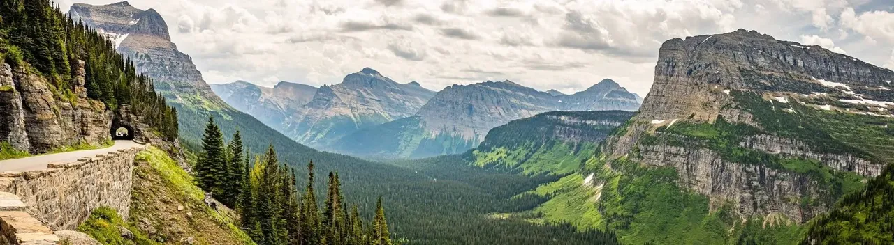
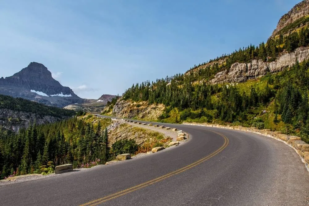 Esta ruta relativamente corta se encuentra en el Parque Nacional de los Glaciares — Shutterstock Longitud: 80 kilómetros Puntos de inicio y fin: West Glacier/Logans Pass, Parque Nacional de los Glaciares, Montana
(EE. UU.) Duración: un día Se trata de una idea tentadora, aunque esconde más de lo que parece. Going-to-the-Sun Road se encuentra en su totalidad en el Parque Nacional de los Glaciares y es la única carretera de EE. UU. que es punto de referencia de la ingeniería civil nacional y de la historia nacional, por lo que es una construcción muy conocida. Entre laderas y descensos escarpados, la ruta se suele hacer de oeste a este y cuenta con bastantes pendientes. La recompensa te espera en Logans Pass, un hermoso prado de flores silvestres rodeado de montañas, aire fresco y (con suerte) cielos despejados. No obstante, su belleza conlleva problemas, principalmente por su popularidad. Sin duda, es mejor hacer la ruta en verano, ya que en invierno nieva bastante y la ruta puede ser intransitable, pero, en verano, hay mucho tráfico (en el propio sitio web se advierte fervientemente que «Solo se planteen recorrer Going-to-the-Sun Road durante la temporada alta de verano las personas con experiencia en bicicleta con tráfico en ambos sentidos») y, además, hay que pagar 20 USD para entrar en el parque. No obstante y a pesar de todo, la ruta es gratificante
y preciosa y se puede ampliar el viaje haciendo uso de las zonas de acampada
que hay en el entorno para senderistas y ciclistas.
Esta ruta relativamente corta se encuentra en el Parque Nacional de los Glaciares — Shutterstock Longitud: 80 kilómetros Puntos de inicio y fin: West Glacier/Logans Pass, Parque Nacional de los Glaciares, Montana
(EE. UU.) Duración: un día Se trata de una idea tentadora, aunque esconde más de lo que parece. Going-to-the-Sun Road se encuentra en su totalidad en el Parque Nacional de los Glaciares y es la única carretera de EE. UU. que es punto de referencia de la ingeniería civil nacional y de la historia nacional, por lo que es una construcción muy conocida. Entre laderas y descensos escarpados, la ruta se suele hacer de oeste a este y cuenta con bastantes pendientes. La recompensa te espera en Logans Pass, un hermoso prado de flores silvestres rodeado de montañas, aire fresco y (con suerte) cielos despejados. No obstante, su belleza conlleva problemas, principalmente por su popularidad. Sin duda, es mejor hacer la ruta en verano, ya que en invierno nieva bastante y la ruta puede ser intransitable, pero, en verano, hay mucho tráfico (en el propio sitio web se advierte fervientemente que «Solo se planteen recorrer Going-to-the-Sun Road durante la temporada alta de verano las personas con experiencia en bicicleta con tráfico en ambos sentidos») y, además, hay que pagar 20 USD para entrar en el parque. No obstante y a pesar de todo, la ruta es gratificante
y preciosa y se puede ampliar el viaje haciendo uso de las zonas de acampada
que hay en el entorno para senderistas y ciclistas.
Costa oeste de Tasmania, Australia
 En esta parte de Tasmania hay bosques y estanques prácticamente vírgenes — Shutterstock
Longitud: unos 800 kilómetros Puntos de inicio y fin: Hobart/Launceston, Tasmania (Australia) Duración: 14—20 días Esta ruta es todo un reto, con la parte occidental de Tasmania alejada de la coste oriental, tranquila y repleta de playas. Desde Hobart y en dirección oeste, dejamos atrás la civilización para adentrarnos en las montañas del parque nacional del Suroeste y el parque nacional Franklin-Gordon Wild Rivers. Pasando vastos lagos y bosques que apenas han visto la mano del hombre, y menos aún las ruedas de una bicicleta de montaña, nos dirigiremos al norte por una antigua vía ferroviaria atravesando el bosque hasta las cataratas de Montezuma, las más altas de Tasmania. Hacia el este, pasaremos bajo el irregular pico de Cradle Mountain, bordearemos los pantanos de Central Plateau y nos dirigiremos lentamente al norte para terminar en Launceston. Y, además del terreno, aquí el clima también es todo un reto. En esta parte de Tasmania, el clima puede ser difícil, con vientos procedentes del océano y temperaturas con oscilaciones más bruscas que en la templada parte oriental. La experiencia es toda una prueba, pero podrás admirar los paisajes más asombrosos del hemisferio sur.
Vía Francigena, Reino Unido, Francia e Italia
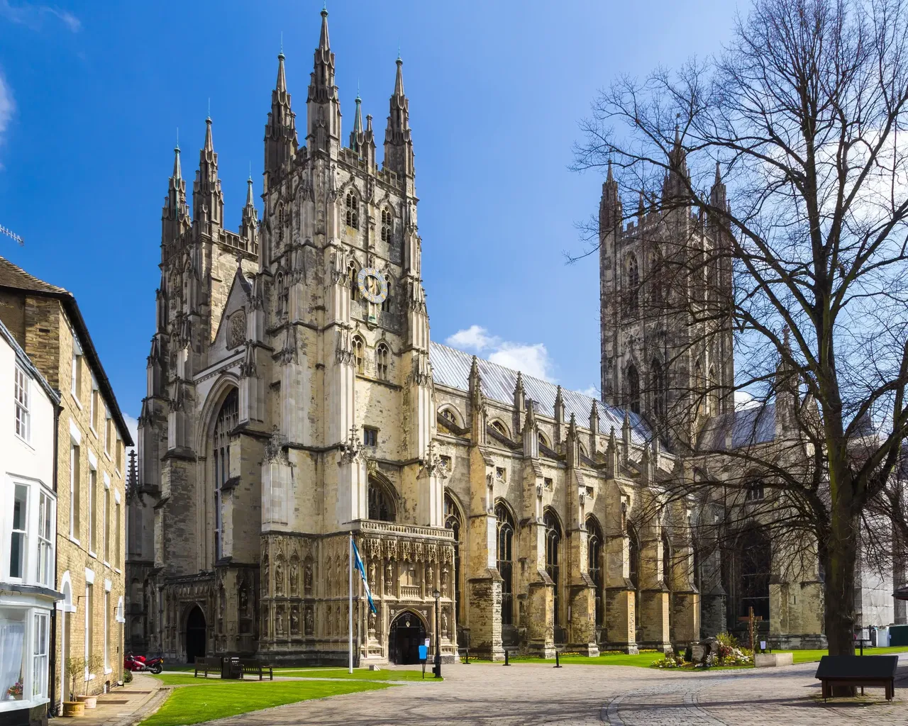 Catedral de Canterbury — Shutterstock Longitud: 1800 kilómetros Puntos de inicio y fin: Canterbury, Inglaterra (Reino Unido)
/Roma (Italia) Duración: 15—20 días Esta es una ruta de peregrinaje que solo hacen unas 1000 personas al año (al contrario que rutas más conocidas como el Camino de Santiago
). La ruta arranca en Canterbury, ciudad del sur de Inglaterra famosa por su catedral y que fue tomada inicialmente en el año 990 por el arzobispo Sigerico, que había sido llamado a Roma
para recoger el símbolo oficial de su servicio. Tuvo la gran idea de anotar todos los lugares en los que paró y que ahora definen la ruta. Cruzado el charco, la ruta se pone seria: el cómodo territorio llano del norte de Francia da paso lentamente a mayores desafíos. Ten en cuenta que tendrás que cruzar los Alpes por el puerto del Gran San Bernardo, a 2469 metros de altitud, y los considerables Apeninos, por el Passo della Cisa, a 1041 metros de altitud. También tendrás que intentar atravesar Roma en bicicleta, lo que puede ser el desafío más grande de todos…
Catedral de Canterbury — Shutterstock Longitud: 1800 kilómetros Puntos de inicio y fin: Canterbury, Inglaterra (Reino Unido)
/Roma (Italia) Duración: 15—20 días Esta es una ruta de peregrinaje que solo hacen unas 1000 personas al año (al contrario que rutas más conocidas como el Camino de Santiago
). La ruta arranca en Canterbury, ciudad del sur de Inglaterra famosa por su catedral y que fue tomada inicialmente en el año 990 por el arzobispo Sigerico, que había sido llamado a Roma
para recoger el símbolo oficial de su servicio. Tuvo la gran idea de anotar todos los lugares en los que paró y que ahora definen la ruta. Cruzado el charco, la ruta se pone seria: el cómodo territorio llano del norte de Francia da paso lentamente a mayores desafíos. Ten en cuenta que tendrás que cruzar los Alpes por el puerto del Gran San Bernardo, a 2469 metros de altitud, y los considerables Apeninos, por el Passo della Cisa, a 1041 metros de altitud. También tendrás que intentar atravesar Roma en bicicleta, lo que puede ser el desafío más grande de todos…
Cuenca Great Divide, Canadá y Estados Unidos
Longitud: 4340 kilómetros Puntos de inicio y fin: Banff, Alberta (Canadá)/Antelope Wells, Nuevo México (EE. UU.) Duración: unos 40 días Esta ruta de puro sabor norteamericano transcurre por senderos rurales en su mes y pico de recorrido por picos montañosos, valles fluviales y carreteras de tierra, pistas y senderos de gravilla. Cruzarás praderas, desiertos, campos y bosques en los que recorrerás todo el espectro de los paisajes norteamericanos , desde la clásica aldea de montaña de Banff hasta el punto de destino, ligeramente decepcionante, un puesto fronterizo andrajoso entre EE. UU. y México . Pero el final es irrelevante. La cuestión es que se trata de una de las mayores aventuras del planeta, una ruta sin duda desafiante, pero que te recompensará con vistas en constante cambio, días sin rastro de civilización y el hecho de estar haciendo algo realmente extraordinario. Como inciso, hay una forma de hacerlo aún más extraordinario: competir en la Tour Divide, una carrera anual para aficionados a la aventura. El récord actual de la carrera completa está en 13 días, 22 horas y 51 minutos. ¡Buena suerte!
Carretera del Pamir, Tayikistán
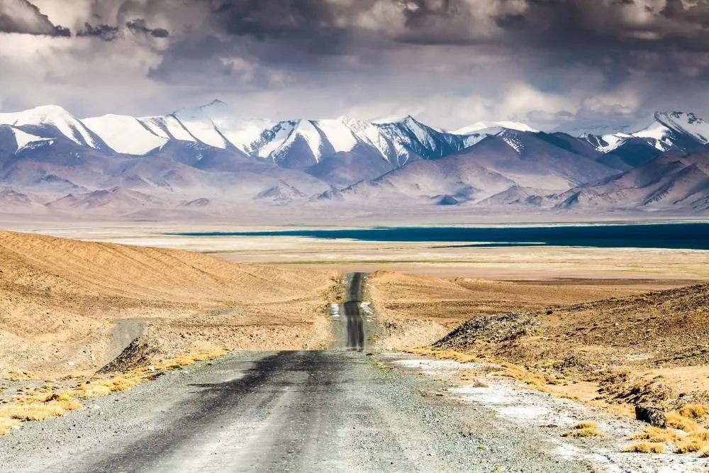 Solos tú y el paisaje inmensamente sobrecogedor de la Carretera del Pamir — Shutterstock
Longitud: 1250 kilómetros Puntos de inicio y fin: Dushanbe/Osh, Tayikistán Duración: unos 20 días Terminamos con uno de los países más ignorados del mundo: Tayikistán. En serio, ¿cuándo fue la última vez que pensaste en Tayikistán? Pues hazlo ahora. En él se encuentra la larga y solitaria Carretera del Pamir, en parte pavimentada y en parte de tierra, y una de las carreteras más remotas del planeta. La carretera cruza vastas llanuras, atraviesa puertos y parece agarrarse a precipicios que te encogerán el estómago . Hay lagos más azules que el cielo, picos cubiertos de nieve y pueblos tradicionales habitados por amistosos aldeanos. De hecho, es probablemente la mejor opción para dormir, ya que los aldeanos son muy hospitalarios y ofrecen estancias en sus propias casas, orgullosos de que visites su espectacular país. Probablemente también necesites equipamiento para acampar, ya que existe la posibilidad muy real de pasar días sin ver a nadie. No se trata de un viaje para principiantes, ya que hay que pedalear a gran altitud, con poco oxígeno. Sin duda, se trata de un viaje único , pero… ¡ten en cuenta en qué te estás metiendo! ¿Te ha gustado este artículo? En Kiwi.com Stories encontrarás más inspiración para viajar.